Kolkata Decoded (Part 5): The Mobility Map of Kolkata
Cities are often understood through their landmarks, neighbourhoods, or skylines.
But there is another map quietly shaping how a city functions every day — the mobility map.
In Kolkata, this map is being steadily redefined by one of the most significant infrastructure transformations in recent decades:
The expanding metro network.
As the city grows and more vehicles enter the roads each year, congestion becomes inevitable.
What changes the equation is not just roads — but high-capacity, high-speed mass transit.
The Kolkata Metro is now evolving into a multi-corridor network that connects:
- Historic cores
- Emerging residential zones
- Business districts
- Future urban hubs
And in doing so, it is fundamentally redefining connectivity across the city.
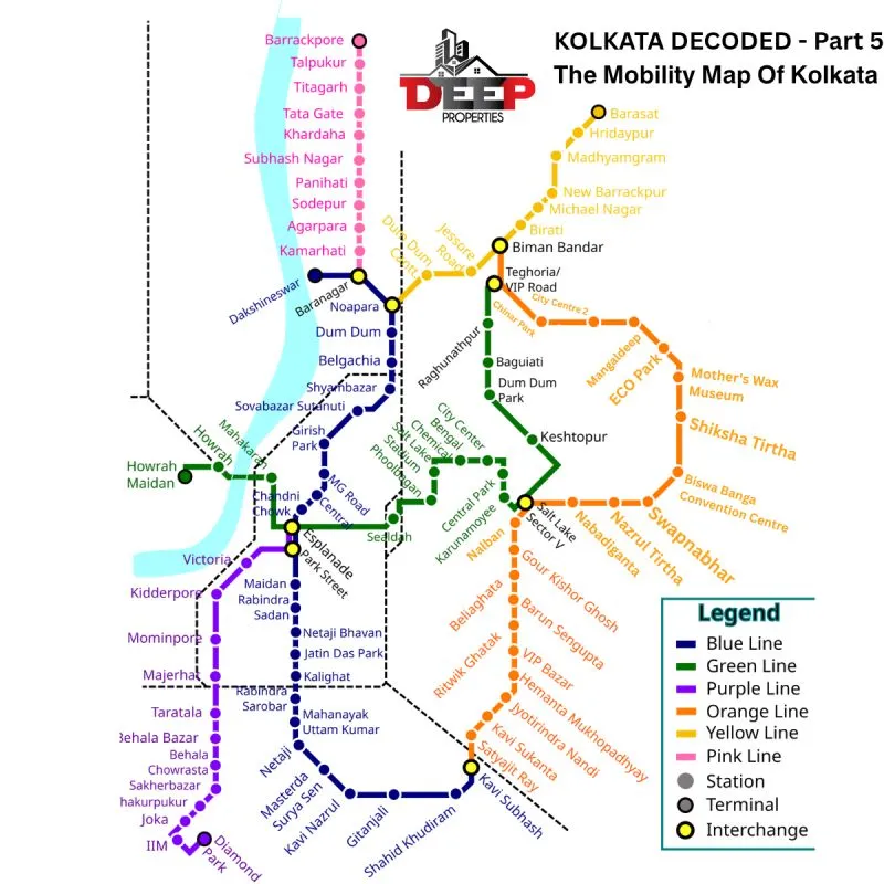
The Metro Lines of Kolkata
Each metro line is not just a transport route — it is a growth corridor in motion.
🔵 Blue Line — Dakshineswar → New Garia
Key nodes:
Dakshineswar – Dum Dum – Esplanade – Kalighat – New Garia
- India’s first metro corridor
- Connects North, Central, and South Kolkata
- Remains the primary commuter spine
This is the original backbone of Kolkata’s mobility system, still carrying the highest daily commuter load.
🟢 Green Line — Howrah → Salt Lake Sector V
Key nodes:
Howrah – Sealdah – Salt Lake Sector V
- Includes India’s first underwater metro tunnel beneath the Hooghly River
- Directly connects Howrah railway hub with the IT district
This corridor is a game-changer, bridging the historic west (Howrah) with the modern east (Sector V).
🟣 Purple Line — Joka → Esplanade
Key nodes:
Joka – Behala – Majerhat – Esplanade
- Expands metro access into South-West Kolkata
- Brings long-awaited connectivity to Behala
This line is expected to unlock residential and infrastructure growth in the southwest belt.
🟠 Orange Line — New Garia → EM Bypass → New Town → Airport
Key nodes:
New Garia – Science City – New Town – Netaji Subhas Chandra Bose International Airport
- Runs along the EM Bypass growth corridor
- Connects southern suburbs directly to IT hubs and airport
This is one of the most strategically important future corridors, integrating multiple growth zones into a single mobility spine.
🟡 Yellow Line — Noapara → Airport → Barasat
Key nodes:
Noapara – Birati – Barasat
- Extends metro access into North 24 Parganas
- Strengthens connectivity toward the airport region
This corridor supports northward urban expansion and suburban integration.
🩷 Pink Line — Baranagar → Barrackpore (Proposed)
Key nodes:
Baranagar – Agarpara – Sodepur – Khardaha – Titagarh – Barrackpore
- Planned along BT Road
- Designed to serve dense residential and industrial zones
If executed as planned, this corridor could significantly improve mobility across one of the most congested northern belts of the city.
The Network Effect
Individually, each metro line improves connectivity.
But the real transformation comes from the network effect.
As these lines intersect and expand:
- Travel time across the city reduces dramatically
- Previously distant areas become accessible
- New residential pockets become viable
- Business districts expand beyond traditional cores
Over time, this creates a powerful shift:
Connectivity begins to redefine location.
Areas that were once considered peripheral start becoming well-connected urban nodes.
Why This Matters for Real Estate
Historically, in every major city:
- Infrastructure precedes development
- Connectivity drives demand
- Demand drives land value
Kolkata is now entering that phase.
Metro corridors are not just transport lines — they are value corridors.
They influence:
- Residential demand patterns
- Commercial viability
- Rental yields
- Long-term investment potential
The Bigger Insight
If earlier parts of Kolkata Decoded helped us understand:
Where Kolkata is structured
How Kolkata expands
This part answers:
How Kolkata will move in the future.
And movement ultimately shapes:
- Growth
- Commerce
- Opportunity
What Comes Next
In the next part of Kolkata Decoded, we will go deeper into:
- Transit-Oriented Development (TOD)
- How metro corridors influence pricing micro-markets
- Where the next investment hotspots may emerge
Because in real estate:
Location matters — but connectivity defines location.
About the Series
Kolkata Decoded is a weekly series on Kolkata Calling by Deep Sarkar, Strategic Real Estate Advisor, who brings a data-backed, analytical approach to understanding the city’s real estate landscape.
The series is contributed pro-bono through Deep Properties, with the goal of delivering clear, transparent, and insight-driven understanding to the community.